
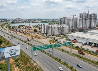
Large infrastructure projects have a long history of reshaping property markets around them — sometimes gradually, sometimes dramatically, and almost never in a straight line. The Bengaluru–Chennai Expressway (officially National Expressway 7, or NE-7) is one of South India's most closely watched corridor projects, and it has understandably generated significant interest in Bengaluru Chennai Expressway property investment. This blog looks at the current, verified status of the project, the genuine opportunities such corridors can create, and — just as importantly — the real risks and due-diligence steps buyers should not skip.
Table of Contents
- Current Status of the Bengaluru–Chennai Expressway (2026)
- How Infrastructure Corridors Influence Real Estate — General Principles
- Potential Opportunities Along the Corridor
- Confirmed Facts vs Market Expectations
- Land-Title Verification — Why It's Non-Negotiable
- Land Conversion and Zoning
- Acquisition Notifications and Land Records
- Access Roads and Connectivity to the Main Corridor
- Development Restrictions and Setback Norms
- Infrastructure Timelines — Water, Power, and Civic Amenities
- Encumbrances and Legal Due Diligence
- Checking Official Records Before Purchase
- Buyer's Due-Diligence Checklist
- Practical Examples
- FAQs
- Conclusion
1. Current Status of the Bengaluru–Chennai Expressway (2026)
As of mid-2026, here is what is publicly confirmed about the project:
- The expressway is a 262–263 km, four-lane, access-controlled greenfield corridor connecting Hoskote (Bengaluru) to Sriperumbudur (near Chennai), passing through Karnataka, Andhra Pradesh, and Tamil Nadu.
- The 71.7 km Karnataka stretch has been completed and was informally opened for local travel from around December 2024, and remains operational for passenger vehicles.
- The Andhra Pradesh stretch is largely complete (roughly 78–85 km), while the Tamil Nadu stretch — the longest segment at around 106 km — has faced delays.
- A legal dispute over a 25.5 km stretch (the Arakkonam–Kancheepuram package in Tamil Nadu) has pushed back the full end-to-end completion timeline. As of mid-2026 reporting, NHAI officials indicated the Andhra and Tamil Nadu packages (excluding the disputed stretch) were targeted for completion around October 2026, while the full corridor's realistic completion has been pushed to sometime in 2027.
- The project cost has also increased over time — from approximately ₹7,811 crore at inception in 2022 to over ₹10,500 crore as of March 2026 for the stretches under dispute/tracking, reflecting the kind of cost and timeline revisions common to large infrastructure projects.
The key takeaway for buyers: parts of the expressway are operational today, but the project as a whole has been repeatedly delayed since it was first proposed (originally targeted for 2024, then 2025, then mid-2026, now pushed toward 2027). Anyone evaluating property near Bengaluru Chennai Expressway should treat "full completion" dates with caution and verify the latest status directly from NHAI or official news sources before relying on any timeline.
2. How Infrastructure Corridors Influence Real Estate — General Principles
As a general pattern (not a guarantee specific to this expressway), improved connectivity can influence real estate markets through:
- Reduced travel time, which can make previously "far" locations more viable for commuting, warehousing, or logistics use.
- Commercial and industrial interest, particularly where corridors are paired with dedicated industrial corridor initiatives (the Chennai–Bengaluru Industrial Corridor is a related but separate initiative from the expressway itself).
- Ancillary development — fuel stations, logistics parks, warehousing, and roadside commercial activity often develop along completed and well-connected stretches over time.
- Gradual land-use shifts, from agricultural to non-agricultural use, in areas that see sustained commercial or residential interest.
These are general tendencies observed around infrastructure projects historically, not assurances of what will happen along this specific corridor, and the pace and extent of such change varies enormously by exact location, existing zoning, and local administration.
3. Potential Opportunities Along the Corridor
Depending on the specific stretch and its stage of completion, potential areas of interest for Bengaluru Chennai Expressway real estate may include:
- Land or plots near completed and operational sections with existing access roads.
- Locations near planned or existing industrial corridor nodes, which may see logistics/warehousing interest.
- Areas with already-regularised land records and clear zoning, which reduce (though do not eliminate) documentation risk.
This is not a recommendation to purchase in any of these categories — it simply reflects the type of factors that are typically considered relevant when infrastructure-linked interest exists. Actual outcomes depend on execution, local development plans, and broader market conditions, none of which can be predicted with certainty.
4. Confirmed Facts vs Market Expectations
It's worth being explicit about this distinction, since marketing materials for "expressway-adjacent" projects often blur it:
|
Confirmed (as of mid-2026) |
Market Expectation / Unconfirmed |
|
Karnataka stretch (~71.7 km) operational |
Overall corridor "opening date" — has moved multiple times |
|
Andhra Pradesh stretch largely complete |
Exact date proposed developments will materialise along the route |
|
Legal dispute over a Tamil Nadu stretch is a publicly reported bottleneck |
Extent and timing of price appreciation in any specific area |
|
Project cost has risen from initial estimates |
Guaranteed development of any particular commercial/industrial hub |
Buyers should treat the right-hand column as speculative, however commonly repeated in brochures or informal market commentary.
5. Land-Title Verification — Why It's Non-Negotiable
Before considering any purchase near the corridor, title verification should include:
- Tracing the chain of title for at least 30 years (the conventionally recommended period) to check for continuous, undisputed ownership.
- Verifying the seller's ownership through the latest Record of Rights, Tenancy and Crops (RTC)/Pahani (Karnataka) or the equivalent land record in Tamil Nadu/Andhra Pradesh.
- Checking for pending litigation, family disputes, or partition issues affecting the land.
- Confirming there are no conflicting claims from co-owners, especially in agricultural land historically held jointly by families.
6. Land Conversion and Zoning
Much of the land along a greenfield expressway corridor may currently be classified as agricultural. Before any non-agricultural use (residential, commercial, industrial) is possible:
- Land conversion (change of land use) approval is generally required from the relevant state revenue/land authority.
- Zoning under the applicable master plan (e.g., BDA/BMRDA-notified zones in Karnataka, or the equivalent local planning authority in Tamil Nadu/Andhra Pradesh) needs to be checked, as it determines what kind of development is even permissible on that plot.
- Buying agricultural land with the expectation of future conversion carries inherent uncertainty, since conversion approval is not automatic or guaranteed, and timelines can be unpredictable.
7. Acquisition Notifications and Land Records
For land near a highway/expressway corridor specifically, it's important to check:
- Whether any part of the land parcel (or adjoining parcels affecting access) is under a pending land acquisition notification for road-widening, service roads, or related infrastructure.
- Survey records to confirm the exact boundaries and survey number match what's being sold — encroachments and boundary mismatches are a common issue in fast-developing corridor areas.
- Whether any part of the land has already been acquired (even partially) for the expressway or related infrastructure, which can affect the remaining usable area.
8. Access Roads and Connectivity to the Main Corridor
Since the expressway is access-controlled, direct entry/exit is only possible at designated interchange points. This is a critical and sometimes overlooked factor:
- A plot's actual usability and access depend heavily on its distance from an interchange, not just its straight-line distance from the expressway.
- Service roads and last-mile connectivity to the plot should be verified physically, not assumed from a map.
- Some parcels that appear "close to the expressway" on paper may, in practice, require a significant detour to actually reach an entry/exit point.
9. Development Restrictions and Setback Norms
Land adjoining a national highway/expressway is typically subject to:
- Control of Access norms and building-line/setback restrictions from the highway boundary, which can limit how close to the road any construction is permitted.
- Restrictions on direct access cuts onto the expressway itself (as opposed to service roads).
- Environmental or other clearances that may apply depending on the specific location (e.g., proximity to water bodies, forest land, or other protected areas).
These restrictions can materially affect what can actually be built on a plot, regardless of its proximity to the expressway.
10. Infrastructure Timelines — Water, Power, and Civic Amenities
Road connectivity alone does not make land immediately "developed." Buyers should separately verify the status of:
- Water supply infrastructure (borewell viability, or connection to a civic water supply scheme where available).
- Electricity connection and transmission infrastructure in the specific area.
- Drainage, sewage, and waste management arrangements, particularly for areas transitioning from rural to semi-urban use.
- Proximity to existing towns/panchayats for basic services (schools, healthcare, markets), since these often lag behind road infrastructure by several years.
11. Encumbrances and Legal Due Diligence
An Encumbrance Certificate (EC) should be obtained for the relevant period to check for:
- Existing mortgages or loans registered against the property.
- Prior sale agreements, leases, or other registered interests that could affect clear ownership transfer.
- Any court attachments or pending decree affecting the property.
An EC should be read alongside title documents and land records, not relied upon in isolation, since it reflects only registered transactions and may not capture every type of dispute or defect.
12. Checking Official Records Before Purchasing Land
Recommended official sources to verify before any purchase include:
- State land records portals (e.g., Karnataka's Bhoomi portal, or equivalent portals in Tamil Nadu/Andhra Pradesh) for RTC/Patta and mutation records.
- The relevant local planning authority for zoning and master plan status.
- NHAI's official website and press releases for verified project status and alignment details (rather than relying solely on real estate marketing materials).
- The sub-registrar's office for encumbrance certificates and registered document copies.
- RERA registration status, where the land forms part of a registered real estate project.
13. Buyer's Due-Diligence Checklist
- [ ] Verify current, official NHAI status of the specific expressway stretch nearest the property
- [ ] Confirm exact distance to the nearest interchange (not just straight-line distance to the expressway)
- [ ] Trace title for at least 30 years and check for disputes/litigation
- [ ] Verify land classification (agricultural/non-agricultural) and conversion status
- [ ] Check zoning under the applicable master plan/development authority
- [ ] Confirm survey number and boundaries match physical inspection
- [ ] Check for pending land acquisition notifications on the parcel or adjoining access roads
- [ ] Obtain and review the Encumbrance Certificate
- [ ] Verify setback/building-line restrictions applicable to the plot
- [ ] Assess realistic timelines for water, power, and civic infrastructure
- [ ] Confirm RERA registration status, if applicable
- [ ] Get all documentation reviewed by a qualified lawyer before payment
14. Practical Examples
- Example 1: A buyer is shown a plot marketed as "5 minutes from the expressway." On inspection, it turns out the nearest interchange is 15 km away, meaning actual access involves a much longer detour than implied — underscoring why physical verification of access matters more than marketing distance claims.
- Example 2: A parcel of agricultural land near a completed stretch is being sold with the promise that "conversion is a formality." In reality, conversion approval depends on the local authority's process and is not guaranteed within any specific timeframe — buyers should treat such assurances with caution and verify independently.
- Example 3: A buyer proceeds without obtaining an Encumbrance Certificate, only to later discover the land was already mortgaged by the seller. This illustrates why skipping standard due-diligence steps — even when a deal looks time-sensitive — carries real risk.
These examples are illustrative and do not describe any specific real transaction.
15. FAQs
Q1: Is the Bengaluru–Chennai Expressway fully open now?
As of mid-2026, only parts of the corridor — primarily the Karnataka stretch and large parts of the Andhra Pradesh stretch — are operational. The Tamil Nadu stretch has faced delays, including a legal dispute over one package, pushing full completion toward 2027 based on current official reporting. This status should be reconfirmed closer to your purchase decision, since timelines have changed multiple times already.
Q2: Does proximity to the expressway guarantee future price appreciation?
No. Infrastructure can influence long-term demand in general, but appreciation is never guaranteed and depends on numerous factors including execution timelines, local zoning, market conditions, and broader economic factors. No location should be treated as a guaranteed investment.
Q3: Can I buy agricultural land near the expressway for future commercial use?
You can, but this requires land-use conversion approval, which is a separate regulatory process and not automatic. Buyers should not assume conversion will happen within a specific timeframe.
Q4: What is the single most important document to check?
There isn't just one — title documents, land records (RTC/Patta), Encumbrance Certificate, and zoning/master plan status all serve different purposes and should all be checked together, ideally with a lawyer's review.
Q5: How do I find the true, current status of the expressway?
Rely on NHAI's official communications and established news sources rather than real estate marketing materials, and check for the latest update since project timelines have shifted several times over the years.
16. Conclusion
The Bengaluru–Chennai Expressway is a genuinely significant infrastructure project with completed and operational stretches already in use, but — as of 2026 — it also remains a work in progress, with parts of the timeline pushed into 2027 due to legal and execution challenges. This mixed picture is exactly why land investment near Bengaluru Chennai Expressway decisions should be grounded in verified facts and rigorous due diligence, not in assumptions about guaranteed future value or optimistic completion dates.
If you're evaluating property near this corridor — or any infrastructure-linked location — Acreok's Buyer 360 service can help you verify land records, title status, zoning, and encumbrances before you commit, so your decision is based on documented facts rather than marketing claims. Careful, independent verification is especially important in fast-evolving corridor markets where information can be incomplete or overstated.
'C' Block, 1st Floor, Unity Building, J C Road, Bangalore – 560027
support@acreok.com
+91 96200 77119





Leave a Reply
Your email address will not be published. Required fields are marked*